Upper Egypt

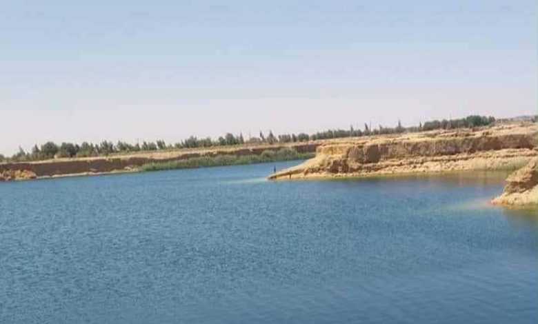
The mysterious “Lake Al-Bahansa”: a natural phenomenon or a hidden danger?

The sudden appearance of “Lake Al-Bahansa” in Minya Governorate, covering an area of approximately 35 acres, has been trending on social media, sparking everyone’s curiosity and raising many questions and speculations. Some see it as a hidden mystery, while others consider it a real danger, especially to the Al-Bahansa archaeological site, which is 5 kilometers away. So what is the secret behind the appearance of this lake and what is its real story?

The enchanting Lake Al-Bahansa

Amidst the sands of the Western Desert in the Minya Governorate, under the golden rays of the sun, the waters of a lake described by locals as the “lake of legends” and “the lake of blessings” sparkle. It is located west of the city of Al-Bahansa, the center of Beni Mazar-Minya, hundreds of meters away on both sides of the desert road (Giza-Luxor).

As soon as it appeared, it became a destination for many locals who flocked to see it, take pictures, and weave stories around it. However, the drowning of one of its visitors and the issuance of a warning statement from the governorate about the dangers of using its waters or swimming in it sounded the alarm.

The origin of the lake

Hassan al-Jallad, a researcher interested in the history of Al-Bahna and author of the book “Al-Bahna, City of Light” for BabMasr, says: “The lake originated in an area that was a sand quarry, which was deepened using excavators and loaders to extract sand. It is surrounded by agricultural land and began to appear four years ago. This was the result of water seeping from higher areas into this low-lying area.“

He adds: ”I contacted the Minya Irrigation Directorate and was part of a committee of experts from the Ministry of Agriculture and the Water Research Center in Cairo, headed by Dr. Salah Al-Karmani, Director of Water Research, and Dr. Sayed Anani from the Drainage Research Institute. The aim was to examine the lake and find out the source of its water.”

He continued: “The examination showed that the bottom of the lake is irregular and reaches a depth of 20 meters. The stone layer has also turned into foam, confirming that it is impossible for anyone who enters it to survive drowning. Officials from the Water and Agricultural Drainage Research Center have warned of this.” He also explained that the committee conducted a survey of aerial maps. It showed that the area was flat land, and after it was used as a sand quarry, small pools of water began to form. Over four years, they grew until they reached their current form.

Lake Al-Bahansa Photo by Salama Zahran, Director of Antiquities, Al-Bahansa
The need to control the lake

According to the committee’s preliminary report, the lake’s water is highly saline agricultural wastewater. The salinity level reached 8,300 parts per million, according to the results of analyses by the Agricultural Research Center in Cairo.

Al-Jallad stresses the need for rapid control of the lake, especially since it is only about 50 meters away from the western railway line, posing a major threat to the railway project.

He pointed out that the high and cracked nature of the Bahna land helped to move the groundwater and gradually collect it until this large area was formed.

The effects of Bahna

The appearance of the lake raised concerns about its impact on the nearby archaeological site, but Salama Zahran, director of antiquities in Bahnasa, reassured Bab Masr in a statement, saying, “The archaeological site is in good condition and far from the lake. It has not been affected by its presence. The Ministry of Tourism and Antiquities has completed the restoration of the shrines of the martyrs of the Companions and Followers.” He explained that Bahnasa is an open-air historical museum that houses artifacts from various eras, starting with ancient Egypt, through the Greek, Roman, and Coptic periods, to the Islamic era, where it includes the tombs of a number of the Prophet’s companions.

He added: “Lake Al-Bahansa did not appear today, but emerged years ago as a result of the accumulation of groundwater and agricultural wastewater in the old sand quarry. The sandy and clayey nature of the soil also contributed to the seepage of water. It is worth noting that the area contains many underground wells that have been in use since Roman times.”

Statement from the Minya Governorate

For her part, Engineer Ikram Mahmoud, head of the city of Beni Mazar, confirmed in a special statement to BabMasr that the phenomenon is natural. She explained that the high salinity of the lake’s water is due to the fact that it is agricultural wastewater.

She added that the governorate issued a statement explaining that the lake was the result of water leaks within a natural geological process. She pointed out that the high salinity makes it unsuitable for human, animal, or agricultural use. She also emphasized that the site is subject to continuous monitoring in coordination with the relevant authorities and that the situation is under control and not a cause for concern.

The emergence of other lakes

Dr. Abbas Sharaqi, professor of geology and water resources at Cairo University, pointed out on his official page last July that Lake Al-Bahansa is not the only one. He noted that there are other lakes in the eastern Nile Valley and on the Sheikh Fadl-Ras Gharib road, with a diameter of about 600 meters.

He explained that these lakes are fed by agricultural drainage resulting from flood irrigation using groundwater from the limestone reservoir west of the Nile. He added that it is not a single lake but a group of lakes that began to form as a result of unplanned local agricultural activity from 2016 until now. He pointed out that the volume of water is increasing day by day with the increase in agricultural areas. This is clearly visible in satellite images.

He added that the lakes are located in deep areas resulting from their dredging as sand quarries, into which agricultural wastewater has leaked, forming lakes whose depth and salinity increase with each passing day. They are not suitable for drinking or agriculture. He pointed out that the increase in salinity is due to the washing of agricultural soil, stressing that although agricultural activity in these new areas is a welcome and positive development, it requires planning, care, and support from the relevant authorities, as well as the regulation of well drilling and the use of modern irrigation methods for sustainable development.

Related Articles

Back to top button
BabMasr