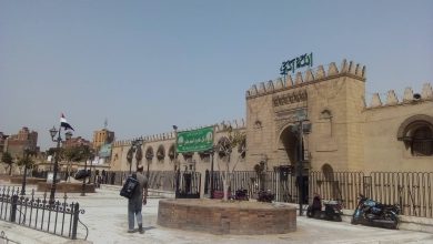
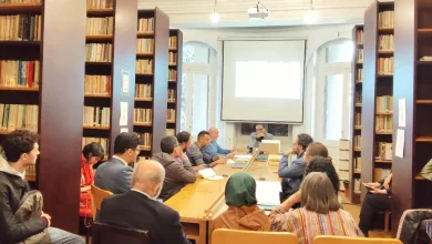
During the “Sayyida Zeinab” exhibition | How can we understand urban transformations by reading old maps?
How can we understand urban transformations by reading old maps? This is what experts recently attempted to answer during an art exhibition organized by the American University in Cairo entitled “Sayyida Zeinab: History, Urban Development Policies, and the Future,” which will be held from August 14 to 15.
The exhibition is a joint collaboration between the American University in Cairo and Oberlin College in the US, with the aim of presenting new historical narratives about the Sayyida Zeinab neighbourhood. Adccompanying the exhibition are events and seminars with the participation of a large and diverse group of specialists, all focusing on the development of the historic neighborhood and its future opportunities in light of the rapid pace of Old Cairo’s transformation.
The fabric of the city
Amr Essam, an urban expert and PhD researcher at the University of Houston, gave a lecture entitled “From Tram to Subway: Sayyida Zeinab Neighborhood in a Hundred Years,” in which he spoke about Cairo’s intertwined urban fabric. He described the city as a stage for successive developments in the transportation network.
He said, “Although neighborhoods such as Ataba and Ramses have a central place in this fabric, or even Heliopolis and Heliopolis, which are closely linked to the tram, the Sayyida Zeinab neighborhood continues to play a vital role in the city’s movement, no less important than the central roles played by other neighborhoods.”
Transportation challenges
He continues: “In the late 1940s, Cairo witnessed the beginning of a traffic congestion crisis. This is reflected in photos of Port Said Street (formerly the Egyptian Gulf) during that period. Photos from the 1920s also show the presence of trams on the same street, before its major expansion, which led to the removal of a historic ”sabil” (water fountain). This indicates the beginnings of planning to address transportation challenges.
Historically, Essam believes that the Sayyida Zeinab neighborhood, along with the Abdeen neighborhood, has historically been classified as a government neighborhood. It was home to a large number of government offices and institutions. This led to a constant demand for movement and transportation, giving it a functional character that attracted large numbers of visitors every day, beyond its status as a mere residential area.
However, the Sayyida Zeinab neighborhood is subject to specific geographical constraints. It is bordered to the north by the Egyptian Gulf Street, which runs from north to south, and to the south by the vast Zeinhem hills. The cemeteries extend to the east. These geographical factors have made the neighborhood, in the view of some, less centrally integrated into Cairo’s transportation network.

Urban pattern
Essam continues: “The 1915 map of Cairo, in addition to the French campaign map (which is considered the first detailed map of the city), reveals the urban pattern that preceded the emergence of the tram. The main population of Old Cairo was concentrated in Al-Gamaliya, Al-Darb Al-Ahmar, Al-Darsah, and Al-Sayeda Zeinab. The outskirts included scattered areas such as Boulaq and Al-Rawda Island. The Muqattam Mountains formed a natural barrier that prevented urban expansion to the east due to the lack of necessary technology at the time.
Maps also show the absence of an integrated road and street network and the spread of agricultural land and ponds. This had a negative impact on the ease of movement between neighborhoods, which were almost closed to their residents. The encyclopedia “Description of Egypt” mentions the craftsmen in each neighborhood.
However, before the advent of the tram, transportation in Cairo relied heavily on “hamara” and “khudhaya” (carriage drivers). They had designated stops in the main squares and city gates, such as Bab Zuweila, Bab al-Nasr, Bab al-Fath, and Bab Saada, closest to Sayyida Zeinab. From there, they transported passengers into the city.
Radical changes
In 1894, the city underwent a radical change with the government’s decision to establish an electric tram system and grant its concession to the Economic Railway Company, led by Belgian Edouard Empain, also known as the founder of Greater Cairo. The tram took Midan al-Ataba as its main hub, from which eight initial lines departed. However, the Sayyida Zeinab neighborhood was not included in these initial lines. This was partly due to the nature of Al-Khalij Street and its difficult access at the time.
But over the course of thirty years, the tram network expanded significantly to cover most of the city’s neighborhoods, even areas that were considered remote at the time, such as Al-Haram. However, the tram company was not without criticism. Despite its efficiency, it was monopolistic, preventing the emergence of other transport companies and attempting to take over any competitors such as bus companies. It also raised fares without sufficiently renewing its system, revealing the two sides of this historic mode of transport.
Elite projects
As for the Sayeda neighborhood, it was connected to the railway network before the tram. The first line of the current Cairo Metro (Helwan-Al-Marg) is essentially an extension of old railway lines. These include the Bab al-Louk-Helwan line and the Ramses-Al-Marg line, which were built during the reign of Khedive Ismail.
In their early days, these lines were elite projects, mainly intended for residents of sparsely populated areas, which included palaces and estates in Helwan, Al-Marg, and Al-Matariya. With the high operating costs at the time, these modes of transport became the preserve of the elite who could afford the travel expenses.
He continues: “Railways in Egypt went through three important stages. The first was coal-powered steam trains, which relied on water vapor for cooling. These trains passing through the city were like a moving factory, producing large amounts of pollution and noise. Since Egypt did not have coal mines, it had to import it.
This led to high operating costs and created a major environmental and health problem, especially in the area between Sayyida Zeinab and downtown Cairo. Old maps show the Sayyida Zeinab neighborhood and its initial connection to the railway. The line that ran around the city extended to connect Abbasiya (where the military barracks were located) with Ramses Station.
Khedive Ismail then extended the line to serve the gunpowder factory in Tura and develop the Helwan area after the discovery of sulfur water there. Although these areas were desert and agricultural, with no passengers, the project continued.
The Helwan Railway Concession
Later, in order to solve the problem of passenger shortages on the Helwan line, a connection was established at the citadel, near the Mahmal in Sayeda Aisha, to facilitate passenger access to central Cairo. However, after the debt crisis, the isolation of Khedive Ismail, and the British occupation in 1882, the government withdrew its support for this unprofitable line.
In this context, the name of Swars, a Jewish millionaire and shrewd businessman who obtained the Helwan railway concession, came to the fore. Sawars realized that the problem lay in the line’s lack of connection to the heart of the city, where government offices were concentrated between Sayeda Zeinab and Abdeen. Therefore, he built a station on Mohamed Mahmoud Street (formerly known as Al-Qasr Street). He connected the line to downtown Cairo and later extended it to Maadi, which was then just a small village. The new line was connected from downtown Cairo to the old line, reaching Maadi.
However, in 1897, a project to fill and drain the Egyptian Gulf emerged, with the aim of combating the cholera epidemic. The tram company took on this huge project under a 50-year renewable concession. The agreement stipulated that the company would bear all the costs of filling, paving, lighting, and any compensation, in exchange for the Egyptian government not receiving any share of the tram’s profits at the outset. This changed later.
The Egyptian Gulf
Amr Essam points out that the Egyptian Gulf was not a regular street, but rather constantly changing, which made it a major engineering challenge.
Project maps reveal that the Gulf was divided into about 15 sections, each requiring different engineering solutions. As a waterway connecting the Ismailia Canal to the Nile, the Gulf was only filled with water during the annual flood season in August, with the water subsequently receding. The bay suffered from waste dumping, which caused the spread of disease.
When it was filled in in 1897, the tram company’s work was limited to filling in the waterway and removing illegal encroachments, without widening the street itself, which appeared in French campaign maps as two streets separated by an irregularly shaped waterway.

Removal of encroachments
According to Amr Essam, photos and maps from the French campaign era show that the Egyptian Gulf was an irregularly shaped street. This reflects its nature as a waterway. When the tram company took over the task of filling in the Gulf in 1897, its work was not limited to filling in the waterway. It also included removing encroachments and urban violations that existed on the banks of the Gulf.
However, it is noteworthy that the company did not significantly expand the street at this stage. The Gulf looked like two streets separated by a waterway. The filling efforts focused on this waterway and removing encroachments that deviated from the approved plan.
The documents discovered, including violations issued by the tram company against prominent figures such as Muharram Pasha Shahin for extending his house into the bay, confirm that this hindered the filling work. This reflects the seriousness of the measures taken. It raises questions about whether these measures were applied equally to everyone. Or are there special considerations for the elite? Although further research is needed to comprehensively assess how these violations are handled, the available information indicates that there is a respectable institutional framework that ensures the orderly application of procedures.
Memory of Place
In another lecture by historian Dr. Shihab Ismail entitled “From Maps of Cairo to Maps of Sayyida,” he argues that maps are more than just beautiful drawings hanging on walls. He believes that maps are more than just beautiful drawings hanging on walls; they are valuable archival documents that give us a deep understanding of the history and urban development of cities. However, they require a critical approach to analyze the information they provide.
Shehab points out that maps reveal details about Cairo that may seem strange at first glance. Near the Sayyida Zeinab Mosque, where the Cancer Hospital is currently located, the area was once occupied by a slaughterhouse. Although it has been removed, the area still has a large concentration of meat traders. This is a clear indication that the “memory of place” continues even after the physical elements have disappeared.
Understanding the needs of local residents
He continues: “The maps also reveal the stories of marginalized areas. Areas such as Tal al-Aqrab, Ashash Zainham, and Ashash al-Saqia, which official discourse has classified as ‘slums,’ are in fact heritage areas dating back to the second half of the 19th century.
These areas, which were inhabited by poor workers and had not seen any development over the years, have recently been demolished, as in the case of Tel al-Aqrab, which has been turned into the “Rawda al-Sayeda” project. This transformation raises questions about the usefulness of demolition instead of dialogue with the residents of these areas to understand their needs and develop their lives.
Map of 1892
Shehab also referred to the 1892 map prepared by French engineer Julien Barrow, secretary of the Ministry of Public Works, as a document of exceptional importance.
Barrois was commissioned to study the sewerage project and prepared this map as part of that study. It served two main purposes: to plan the sewerage network with precision, allowing the location of pipes and their relationship to buildings and ground levels to be determined with extreme accuracy; and to develop the tax system, with the aim of modernizing the property tax system in Cairo. The cadastral map showed the name of the owner of each plot of land.
The second objective was to develop the tax system, with the aim of modernizing the property tax system in Cairo. The cadastral map, which shows the name of the owner of each plot of land, was an effective tool for raising property taxes from 8.5% to 10%. The increase was earmarked to finance the maintenance of the sewerage project.
The story of the search for the 1892 map also reveals the challenges associated with accessing historical documents in Egypt. After years of searching in the National Archives, Shihab Ismail found the complete map at the Survey Authority. Alongside other treasures from Cairo and the whole of Egypt, the maps have been digitally preserved in their original form. However, obtaining complete copies of these maps is no easy task. There are difficulties related to the “property maps,” which are the most expensive and closely guarded by the Authority.
Real estate bubble
During his lecture, Shehab also pointed out an important point: between 1897 and 1907, Cairo experienced an unprecedented “real estate bubble.” Land prices in some areas increased tenfold, and the city underwent rapid cycles of construction and demolition.
During this period, entire suburbs such as Garden City, Maadi, and Heliopolis developed. The Ismailia neighborhood also changed radically. Huge palaces and villas were demolished and replaced by high-rise apartment buildings with high population densities. This shaped the features of downtown Cairo as we know it today.
This urban development coincided with a major development in transportation infrastructure. Tram lines were laid, and the Egyptian Gulf and many canals and ponds were filled in as part of a broad urban expansion and construction program.
In the midst of this expansion, the Survey Department (now the Survey Authority) was established in 1898. One of its main tasks was to assist the Ministry of Finance in reassessing property taxes in Cairo, Alexandria, and other major cities. It used a modern system based on maps. Previously, property documents and tax records had lacked accuracy and relied on textual descriptions and croquis drawings.
He concludes by noting that the Survey Authority adopted a geometric grid system to cover the entire Egyptian territory with maps. The British administration was interested in this development to ensure that it benefited from the added value generated by large infrastructure projects, such as the Aswan Dam, which led to higher agricultural land prices and increased cotton production, thereby increasing revenues.
Hi, this is a comment.
To get started with moderating, editing, and deleting comments, please visit the Comments screen in the dashboard.